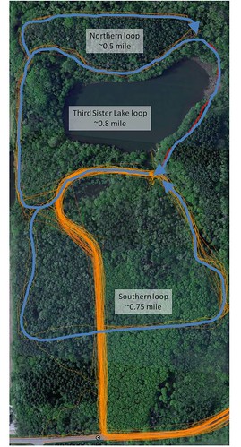
 With the completion of the boardwalk structure (and the hopefully quick completion of the connecting pathway), there is a new loop path within Saginaw Forest. The figure to the left is based on a compilation of paths taken using my (rather basic) GPS unit, and as such, it should not be considered an official map of the paths in Saginaw Forest. It does, however, illustrate the three distinct loops that people can walk within the property: Northern loop (~0.5 mi), Third Sister Lake loop (~0.8 mi) and Southern loop (~0.75 mi).
What isn't shown is the walking path through the "Arboretum" section of the facility, where the wooden "teepee" stands. This little detour doesn't add that much to the length of the Third Sister Lake loop.
The pathways are not absolutely correct, because my GPS unit isn't the best one that money can buy (I'm just a poor grad student, after all), and, because of this, the tree cover seriously hampers the ability of the unit to get a good fixed signal. Also, the lengths are rough estimates, made by using the distance tool in Google Earth. Still, I think that it does a good job of showing the rough distances that each of the three (!) loops are.
The length of the "outer loop" is roughly 1.3 mi.
The distance from the gate to the cabin is roughly 0.45 mi.
Distance from the gate to the cabin and along the "outer loop" (returning to the cabin) and then back to the gate is roughly (0.45 mi +1.3 mi +0.45 mi) 2.2 mi.
Now, if someone wanted to do an interactive and informative map of Saginaw Forest to take with you on that 2.2 mile trek, that would be awesome!
No comments:
Post a Comment