Over the years, buckthorn has invaded the edges of the roadway to the cabin. Some of the boles of the shrubs have gotten thick enough, and their branches thick enough, that they are seriously crowding out the cedars that were originally planted to line the roadway (although perhaps a little too close to each other).
I decided to clear out some of these buckthorn -- located in the break between two cedars. You can see them slowly disappearing from view. It feels good, and that the wood will eventually be used for the SNRE campfire event makes for an even better feeling.
Wednesday, July 28, 2010
Thursday, July 22, 2010
Tree trimmers in the forest
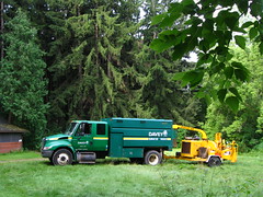 I had a knock on the door at 8am this morning, and -- puzzled -- I opened the cabin door and saw a man with a hard hat, wearing a reflective vest. He was here to trim trees along the power lines and had followed in the power lines from the split-off point on Wagner, and would it be possible to access the property via the road? Sure, and I went to get the gate lock.
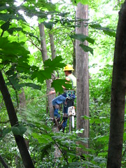 A little time later, in drives their truck and they set up in the front lawn. They immediately got to work, trimming away the trees near the power lines, slowly working their way out to the property line with PALL. They are working at cutting the trees as minimally as possible, except when they have to cut down a tree, or when they are asked to remove one. They will eventually also work along the property line, following the power line. Although this doesn't appear to actually be part of the management plan, it is something that really needs be done, since trees do continue to grow, and it has been at least two years since the trimmers were out here last.
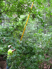
Wednesday, July 21, 2010
Cutting sumac
Goodness but there is a lot of sumac in the front area. Over the years, these sumacs have taken over the mid-level canopy, brambles had taken over the same groundcover real estate. All of this growth has slowly been encroaching in on the lawn area. (Was there more lawn back in 2004, when I came out here for a campfire event? I can't, in truth, remember.)
Anyway, I took the saw to some of the sumac and the scythe to the brambles before carting several wheelbarrow-fulls of plant matter to the fire pit. In amongst all of that, I found that there were several vines that had crept into the sumac with runners infiltrating what looks like much of the ground in the area (that's going to be really annoying to deal with in the future unless I can pull up most of it).
After a couple bouts each of an hour's work, I think that things are going well (enough) with the cutting-back-of-the-plantlife. Especially with the management plan construction coming up, I think it would be a good thing to deal with now.
Bing has some nice "bird-eye" photos of Saginaw Forest
One difficulty that I sometimes have in describing the location of the caretaker's cabin in the forest is that it is so closely hemmed in by trees on three sides, meaning that the only easy way to see the place from the sky is from an angle looking southward (from somewhere north of the cabin).
Bing's maps allows one to rotate the view of aerial photographs to see "bird's eye" views of an area. Here are two views of Saginaw Forest and the caretaker's cabin taken from Bing.
 Cabin clearing looking southward.
 A view of the fetch of Third Sister Lake looking eastward. The cabin and the clearing can be seen toward the upper-right of the picture. The gray slightly elongate blob toward the bottom-right of the photo is the frog pond.
These photos seem to date from the previous caretakers' tenure. However, not a whole lot has changed from that time. (Of course, the building of a boardwalk along the eastern end of the lake, and a dock on the lake will alter things a little bit...)
Bing's maps allows one to rotate the view of aerial photographs to see "bird's eye" views of an area. Here are two views of Saginaw Forest and the caretaker's cabin taken from Bing.
These photos seem to date from the previous caretakers' tenure. However, not a whole lot has changed from that time. (Of course, the building of a boardwalk along the eastern end of the lake, and a dock on the lake will alter things a little bit...)
New Worldwide NASA Forest Mapping
NASA announced that they have completed their global forest height mapping project. Looking at the main project page, there is a map of the contiguous United States' forests, and it is possible to see the little speck of green that is Saginaw Forest -- and a statement of the current extent of forest cover in a state that used to be blanketed with forests.
New Layout
I got bored with the layout of the blog and found that blogger had a bunch of new templates. Unfortunately, I couldn't figure out how to put an actual photo from Saginaw Forest in as the background, though.
Tuesday, July 20, 2010
Heavy rains
Heavy rain fell on Saginaw Forest last night...
... which meant that the log jam I broke through this past weekend got washed out to the lake (thus saving that section of bank from further erosion) ...
... but sediment flow into Third Sister Lake continues, and it's all coming from within Saginaw Forest. However...
... the morning mist on the lake is quite pleasant ...
... and the cabin clearing is quite peacefully serene.
Sunday, July 18, 2010
Cleared part of a log-jam
Over the past number of storms, a bunch of woody debris has gotten jammed in the stream, near the fording. These pieces of wood have created a barrier for free-flow of water, and -- like water is wont to do -- erosion is taking place around the jam, wearing down one of the stream banks. A lot.
Trying to pull the jam apart proved to be next to impossible: too much water had flowed passed, jamming twigs and sediment into the interstices, until it was as strong as a beaver dam. (Have you ever tried pulling one of those things apart? It's next to impossible!) So, I pulled out the hand saw and just cut a channel through the sand and wood, pulling out some surprisingly large-diameter branches during the process. I managed to clear a small channel, which I hope will then help scour out the rest of the jam. (Of course, if more damming materials come in from upstream, this would have been a futile activity.)
This fording will eventually have a bridge over it, and I would imagine that the construction will remove a large chunk of the woody debris as well as the fallen trees nearby. Still, the problems of storm-water scouring remains a problem...
Friday, July 16, 2010
Research in the forest
Recently, I encountered Liz Schultheis, a doctoral student from MSU who was doing research on Norway Maple invasion. Here is a description of the work that she is doing -- that includes Saginaw Forest, as well as the parks and natural areas around Ann Arbor. Here is her description to me about her research:
My research is on the invasion of Norway maple in Michigan. Specifically I am sampling as many sites as I can find to get a variety of invasion dates to create a time series. I am looking to see if Norway maples experience enemy release early in their invasion, but then acquire them over time as native soil pathogens and predators evolve to use a new resource. From each forest I sample I core trees I believe to be the oldest, collect soil samples, and measure DBH and tree density.

Besides the large invasion of Norway maples right at the forest entrance, we found even older trees in the south-west corner across from where we parked [on Westview Way]. The largest DBH I could find was 61.3 cm, and this was our largest reading from any of the Ann Arbor parks. I plan to use my tree core to date this tree, and ... estimate the invasion of Norway maple into your forest.The photo in this post was taken by Liz, showing her undergraduate research assistant, Jeremy Jubenville, taking a soil core next to one of the larger Norway maples in Saginaw Forest. (Thanks to both for letting me use this photo.)
Wednesday, July 14, 2010
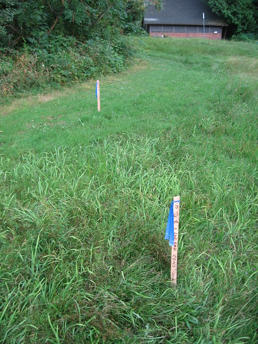
Survey posts in the front lawn
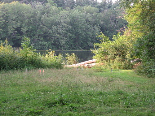
There are survey-cast posts on the front lawn that label where the upcoming path and dock will be. Hopefully, this will mean that the time-line for the construction will not be moved even closer to autumn... We shall see.
Wednesday, July 7, 2010
Hot days
These hot days in Ann Arbor saw the temperature reach the low 90s Fahrenheit (low 30s Centigrade). Without any air conditioning in the cabin, one would that it would end up being very hot inside. However, it hasn't been too bad, because, being surrounded by mature trees to the south and the north, the cabin stays in shade for much of the day, meaning that the heat gain isn't too bad. (This could be a problem if SNRE wanted to install some solar panels.) Furthermore, although the roof insulation isn't the best in the world, the thick stone walls don't really allow for much heat gain, either.
On the inside, I am running a de-humidifier, something that is especially necessary when living so close to a lake (evaporation) and surrounding trees (respiration), both of which make humidity much higher than in the surrounding area. Still, with the de-humidifier running, I'm able to keep the humidity at 70%, although after only 10 hours, the 50 pint (23 liters) reservoir is 1/4 full!
When walking outside last night, the damp clung to me and the insects, frogs, and smell of the evening humid air took me back to nights on Guam.... ah, nostalgia.
Friday, July 2, 2010
Fisherman at TSL
I found a man fishing in Third Sister Lake. He said that he had a State of Michigan fishing license. Okay. Good. But did he have a University of Michigan collecting license? No, he didn't. Well, I asked him to put back the fish he caught, and in went several bluegill.
If you want to fish, in Third Sister Lake, you cannot do so from Saginaw Forest. Walking upstream from Honey Creek -- through the farm fields, and into the forest -- and staying in the water the whole way is the only way that you can (legally) fish in the waters with only a Michigan Fishing License. Of course, that would require that the entire stretch be classified as "navigable"... which it isn't.
If you want to fish, in Third Sister Lake, you cannot do so from Saginaw Forest. Walking upstream from Honey Creek -- through the farm fields, and into the forest -- and staying in the water the whole way is the only way that you can (legally) fish in the waters with only a Michigan Fishing License. Of course, that would require that the entire stretch be classified as "navigable"... which it isn't.
Subscribe to:
Posts (Atom)