While not a blizzard, the snow continues to fall on the forest. It's a little reminder of the continued presence of winter -- much of last week was spent just above thawing, and large patches of the area in front of the barn had become brown and melted out; the road was well on its way past slush and one could almost start thinking of spring. Now, there's several inches of powder, with no real let-up in sight.
I've called for the plows, but they don't appear to be able to get to me too quickly...
Monday, February 22, 2010
Tuesday, February 16, 2010
An initial description of Third Sister Lake from 1904
The first scientific description of Third Sister Lake occurred in 1904, written by Lewis H. Weld in the journal Botanical Gazette in a paper titled "Botanical Survey of the Huron River Valley. II. A Peat Bog and Morainal Lake" (true, it is a description within the context of a detailed description of First Sister Lake). The description extends out toward First and Second Sister Lakes, but the general descriptions are quite interesting, from the point of view of history - both of the area as well as a description of land cover.
West of the second, a quarter of a mile away, is the third lake, the largest and deepest of the group. It is not connected with the other two, a low, gravelly ridge separating it from the marsh just east of the woods, through which the other outlet flows. The outlet of this third lake flows through a bog at its western extremity, then to the southwest, where it makes a great bend through a level plain; then, after two or three miles, it turns north again, joining the outlet of the other two and forming a branch of Honey Creek which empties into the Huron River about a mile above Foster's.
The levels of these lakes are approximately the same, ie, 914ft (278m) above sea level or 33ft (10m) above the bench-mark on the library building of the State University, and 120ft (36.5m) above the Huron River at the outlet of Honey Creek. The summit of the divide east of the first lake is 955t (29Im) above the sea, or 41ft (12.5m) above the lakes. The corner on Liberty Street, one mile South of Huron is 979ft (298m) and the kame just south of Liberty Street rises probably 75ft (23m) higher. It was once proposed to derive the water-supply of Ann Arbor from the third lake, pumping the water to a reservoir on top of this kame, about 140ft (42m) above the lake.
Ordinarily the level of the three lakes remains nearly constant throughout the year, becoming, however, 6 to 8in (15-20cm) higher in the spring. In the fall of 1901 the lakes were said to be lower than they had been in years. It is popularly supposed that they are fed by springs, but careful testing with a thermometer, in the fall of the year, has thus far failed to detect the influence of such springs. It is a very common thing, however, for lakes of this sort to be sub-irrigated, that is, water percolating through the stoney clay of adjacent hills makes its way to the lake, and, owing to the higher water-table on all sides, maintains the level constant in the lake basin. Another thing which helps to retain the water is the fact that the bottom of the lake basin is filled with a deposit of blue clay which prevents leaching. The depth of the lakes varies with the size, the first being 18ft (5.5m) deep, the second over 35ft (10.5m), and the third 55ft (16.75m).
This group of lakes is of glacial origin, like numerous other small lakes of Michigan. They lie on the western slope of the terminal moraine which was formed by the Erie lobe of the icesheet, and which now extends northeast and southwest across the county. Just south of the second and third lakes is a high kame, and these lakes lie in some of those local depressions in the drift which are characteristic of a kame area. The present outlets follow the glacial drainage channels. These flowed away from the ice front to the north and northwest to the Huron River, which at that time had just formed in the re-entrant angle between the Erie and Saginaw lobes and flowed to the west through the Portage and Grand into Lake Michigan. All the region east of this terminal moraine, including Ann Arbor, was then occupied by the ice sheet, and the glacial drainage was to the west.
...
The Three Sisters were then originally two lakes, the third, which has always been separate, and one from which the first and second and the marsh north of the road have been derived. The original lakes were some 5 to 6ft (1.55-1.8m) higher than at present, as is shown by a beach or terrace north of the second lake, and by other evidence. Their lowering is apparently due in great part to better drainage since open ditches have been cut in the outlet channels.
[In summary] The third lake never was connected with the others. The first and second were once one, with an island in the center. Subsequent lowering of water and filling of channels has made two lakes.
EMU limnology class field lab visit
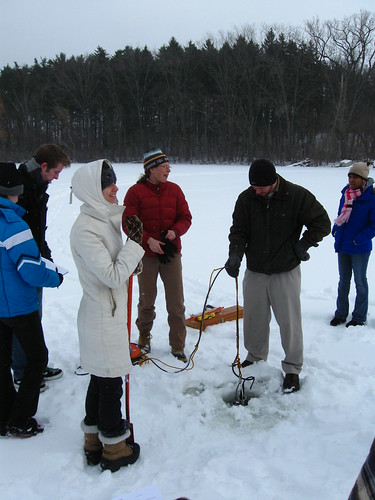
After walking out with them, I took some photos of the class before retreating back to the relative warmth inside the cabin.
Tuesday, February 9, 2010
Snow, snow, snow again
There's already a couple of inches of the white powder on the ground, and up to five more to come over night. Originally, an EMU limnology class was supposed to come out to Saginaw Forest this week, but due to the weather, they will be postponing their trip and will come next week, instead.
The plows are supposed to come tomorrow morning - hopefully after all this storm is over. It looks like I might be snowbound today...
The plows are supposed to come tomorrow morning - hopefully after all this storm is over. It looks like I might be snowbound today...
Wednesday, February 3, 2010
Snow overnight. Called in the plows
Round two of winter: snowfall again after a brief reprieve from the stuff during the latter half of January. I just called the plows to come out -- hopefully they will be able to clear the road and turn-around today.
In the first instance of snow, I didn't call them in and it eventually turned into trampled ice that stayed around longer than I would like. Therefore, now, whenever there is more than a dusting of snow, I will call in the plows. It makes the road much safer for any researcher, class, or delivery vehicle which doesn't have heavy-duty ice-and-snow-ready tires.
In the first instance of snow, I didn't call them in and it eventually turned into trampled ice that stayed around longer than I would like. Therefore, now, whenever there is more than a dusting of snow, I will call in the plows. It makes the road much safer for any researcher, class, or delivery vehicle which doesn't have heavy-duty ice-and-snow-ready tires.
Subscribe to:
Posts (Atom)