Friday, April 30, 2010
Working on mapping the forest (update 1)
The mapping process plods on -- slowly. At the property management meeting at the start of the week, I was introduced to the mapping project of the SNRE properties that is going on presently with Dr. Bergen, and I really would like to get my hands on some of that spatial data to ensure that I'm not doing the same work.
Thursday, April 29, 2010
Weeding
Did a bunch of weeding of garlic mustard this morning, and added to them the growing pile for burning. ... perhaps tonight.
Speaking of garlic mustard, most of them are flowering right now: little balls of white flowers that (remarkably) continue to grow toward the light, even if they are uprooted and thrown to the side.
Speaking of garlic mustard, most of them are flowering right now: little balls of white flowers that (remarkably) continue to grow toward the light, even if they are uprooted and thrown to the side.
Monday, April 26, 2010
Management meeting
A sunny day... A little brisk out, but the sun should help keep me warm. This morning, I spent time working with the property committee discussing various things vis-a-vis data management in the forest. I learned that K. B. has many, many data layers of land cover of Saginaw Forest going back to the 1940s (and digitized land-cover layers). Then, in my own wanderings around the forest, I encountered many things indicating different studies going on in the Forest (and possibly from bygone days). The need for some standardized idea of the type, extent, and experimenters out in the forest - as well as the length of various studies - would make for a good addition to the types of data that the caretaker could be in charge of.
Picking garlic mustard... got something else
These past few days, I've been nursing a small case of poison ivy that I apparently picked up while uprooting some garlic mustard. Yay... Another sign of spring. Somehow, though, it doesn't make me very happy...
Tuesday, April 20, 2010
Lost data
This morning, I went out and collected GPS data points from throughout the forest, and I downloaded them onto my computer and transferred them to the correct data format for use in ArcGIS. However, I saved them as "tracks" instead of "points", and so when I cleared the data from the GPS unit (thinking that I had actually saved all the data), they were gone.
A whole morning of trekking through the forest and collecting spatial data and making notes of each of the points: gone. Oh well, at least I now know where most of the special trees are. And at least, the line for the paths was saved, so I am getting an ever-better representation of the trail-network in the forest. (Silver lining.)
I need to finish the work on the GIS work this weekend, which means forest treks later this afternoon.
Monday, April 19, 2010
Working on mapping the forest
Today and tomorrow, I'll be out mapping the forest for a better understanding of what projects are being undertaken out in the forest in order to better determine what sorts of things will be able to be done viz the management plan.
There are some problems that I've run up against with regard to using the GPS unit. First of all, the ever-greening forest canopy creates some havoc with the satellite acquisition, thus making the points somewhat problematic. A second one is that the program that Garmin uses can export to Google Earth, but not to the ArcGIS software that I am using for the analysis. This means that I have to do spatial projections and re-projections, and through all of these processes, the end results are not as accurate as I would like them to be. Still, they are better than nothing.
Another problem is that of the sampling rate at which the Garmin unit takes measurements. The unit only samples so many times per minute, which means that if I move through the forest quickly (i.e., run or cycle), then the paths it maps are very point-deficient, and this is exacerbated by the low signal strength caused by the canopy (see above). However, if I move more slowly, I should be able to get a better resolution on the site, but if I move slowly through an area with a dense canopy, the measurements will not be accurate. This means that, while I may have more points (and therefore potentially a higher level of resolution), these points may not be as accurate, meaning that they might not be very useful.
A third problem is that of the spatial projection. The Garmin unit takes latitude and longitude measurements. (It also takes elevation measurements, but these are not very good, since they depend somewhat on air pressure, making the measurements inconsistent, especially at fine scales.) However, the ArcGIS program needs to have the data projected onto a mapping coordinate system. First, though, in order to feed the data into the ArcGIS program, it needs to be in a format that is recognized, and this requires the use of another program (GPS Utility), and this utility uses a particular datum, the projection from which into the Michigan GeoRef coordinate system means that there is some slight shifting that needs to manually be accounted for.
Put all these together (canopy-related signal impedance, spatial resolution, and spatial projection), and the process of translating on-the-ground measurements into a mapping system makes for a slightly annoying process (even if it is a lot more simple than in decades past).
Saturday, April 17, 2010
Friday, April 16, 2010
Garlic mustard: PULL THEM OUT!
 The perennial bane of Saginaw Forest -- garlic mustard --is back, along with the spring. Growing primarily in places where there re gaps in the canopy, they are especially thick along parts of the main road, as well as near the cabin. While I am trying to minimize the amount of the stuff in front of the cabin, there is already a lot of the stuff that can be found throughout the forest, and it isn't possible for a single person to get all of it without the expenditure of a LOT of effort each year.
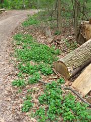
If you would like to help out with some of the maintenance and preservation of the Forest, then I would ask that you pull these weeds out whenever you see them and pile them along the path. I will come by and collect them every few days until the earnest start of summer. What does garlic mustard look like up close?
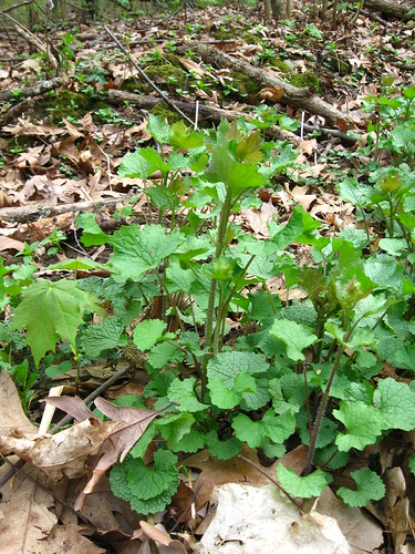
Well, they have broad, somewhat heart-shaped leaves with a serrated edge. As you can see from the photo above, they usually occur in tight clumps of plants, and so if you see one, you will quite likely encounter others nearby. When the are in bloom, their flowers are at the very top of a long stalk and are small and white. Presently, though, they are not quite in bloom:
The best way to pull these plants (and most plants) is to pull as much of their roots out of the ground, holding the plant at its base (i.e., where the plant comes out of the ground).
Right now, one management goal is to try and ensure that no garlic mustard becomes established on the north side of the property. Therefore: if you see some growing there, please go ahead and pull them out by the roots. Just make sure to pile your pullings by the side of the path.
Tuesday, April 13, 2010
Monday, April 12, 2010
Third Sister Lake map
A number of decades ago, the state DNR did surveys of the inland lakes of Michigan. In amongst those lakes they surveyed was Third Sister Lake. A basic bathymetric map of the lake can be found here.
Saginaw Forest activities and management plan
There's been some activities in Saginaw Forest with regard to maintenance activities. This is part of the new management plan that's been drawn up for the forest. Last year, 2009, leaning trees were cut down in order to minimize the risk of having one fall unexpectedly. This year, there's a good chance of a boardwalk going in on the east side of Third Sister Lake - connecting the north and south side of the lake, creating a circle route.
If you are interested in looking at the plan, it can be found here.
If you are interested in looking at the plan, it can be found here.
Sunday, April 11, 2010
Wonderful weekend weather
There's been wonderful weekend weather, and this has brought in a lot of new and returning users to Saginaw Forest. This has meant re-educating people as to the use of Saginaw Forest. Basically, it's not their property, and they need to follow the proper rules of use.
These include keeping one's dog leashed (not merely having a leash on the dog, allowing it to run free), and to recognize the open hours of the forest are from 6am to 6pm.
These include keeping one's dog leashed (not merely having a leash on the dog, allowing it to run free), and to recognize the open hours of the forest are from 6am to 6pm.
Sunday, April 4, 2010
Easter in Saginaw Forest
 It's Easter Sunday in Saginaw Forest, and after returning from brunch in town, I decided to do a project: clearing out some of the brambles that are slowly overtaking the area east of the campfire. While the brambles do provide a nice source of berries during the summer, I'm not the only one enjoying them. Birds like to get in there and eat the berries, and poop the seeds out elsewhere in the forest. This has led to brambles cropping up throughout the forest, like weeds. While I don't think that I will be able to halt the expansion of the brambles in other parts of the forest, I know that I can stop them here in the front of the cabin. Therefore, I chose to remove brambles at this time only from a smallish triangle of land that is right next to the path that leads out to PALL. It was full of brambles and one largish rose, and since the path to PALL is also the path used by SNRE students during the annual campfire celebration, I felt that it would be good to get rid of any prickly things that could snag on students' clothes as they enter and egress from the property. (How about that: a nice pat on my back.)
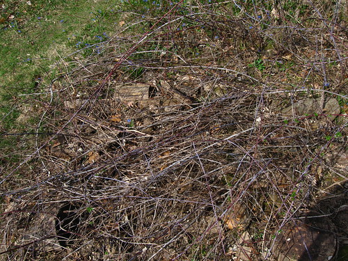
These brambles were also in a rather sunny part of the yard, and so if I were to choose to plant some vegetables, they might be best planted in that area -- in the light, but with some sort of fencing to keep out the dogs and groundhogs. (As for the squirrels, I doubt that much of anything can keep them out.)
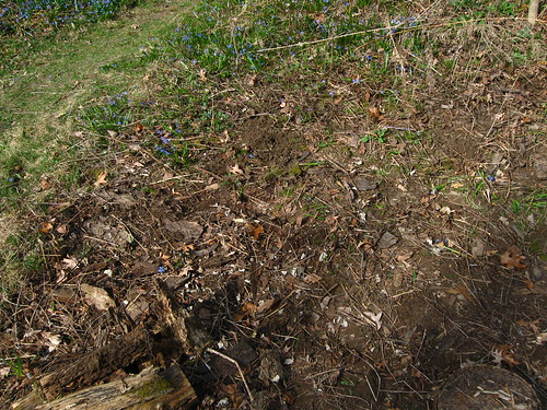
After about an hour's work, I had removed all of the above-ground brambles and cut back the rose. I also uncovered a lot of dead wood that could be used to help burn all of the brambles that I pulled. I'll have to go over the area with a rake to get the rest of the small debris, and a hoe or tiller to pull up the root systems if I want to plant there. We'll see, though.
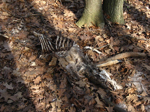
While doing my rounds (there is a definite up-tick in the number of visitors this weekend), I brought my camera along to photograph the dead deer remains that are near the front gate. Kind of sickening, but it's all natural decay. And it's proof of a sort that I get deer in the forest on occasion. What killed it though and how long it's been there I don't know. I only know that I saw it after the snows had melted, but it could have been a casualty that walked onto the property during hunting season.
Subscribe to:
Posts (Atom)